
About
Researchers at King Abdullah University of Science and Technology (KAUST) have developed a joint trajectory-and-resource optimization framework that enables a high-altitude platform station (HAPS) to carry out synthetic aperture radar (SAR) sensing while carefully managing the limited energy available for flight, radar operation and communication.
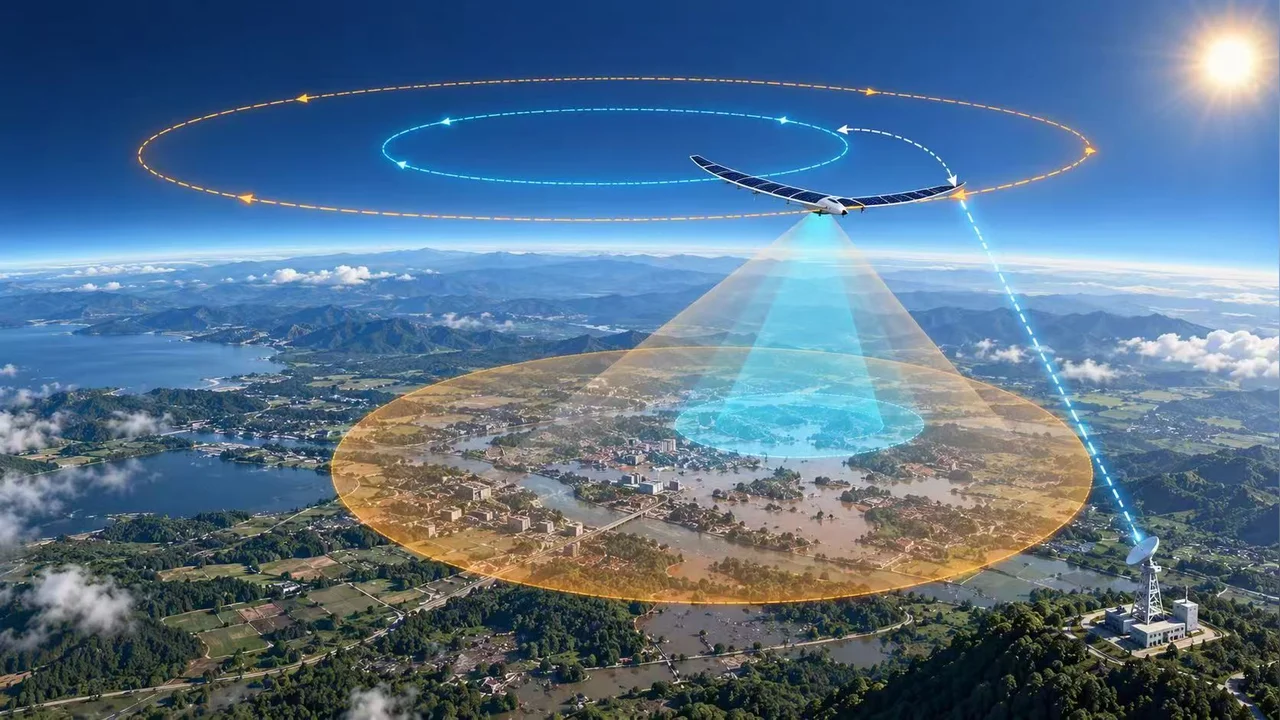
The team, including Bang Huang, Ki-Hong Park, Xiaowei Pang and Mohamed-Slim Alouini, investigated how solar-powered HAPS aircraft operating in the stratosphere, typically around 20 to 30 kilometers above the ground, could carry SAR payloads to provide fast, persistent and all-weather situational awareness after disasters such as earthquakes, landslides and floods. When a disaster strikes, both speed and reliability matter. Satellites can observe very large areas, but their revisit opportunities are constrained by their orbits. Low-flying UAVs can respond more flexibly, but their endurance and operation may be limited by high winds, heavy rain and other adverse conditions. HAPS offer a complementary option: they can remain over a region for extended periods while operating above most weather systems. SAR adds another advantage. Unlike optical imaging systems, SAR can operate day or night and does not require clear skies. A HAPS-borne SAR system could therefore continue observing disaster-affected areas when clouds, rain or limited visibility make conventional optical sensing more difficult.
Realizing this concept, however, requires several tightly coupled design decisions. The HAPS must follow a trajectory suitable for SAR imaging, allocate sufficient power to radar sensing and communication, and remain within a limited energy budget. In the proposed architecture, raw SAR echo data are transmitted to a ground base station for image reconstruction, reducing the onboard processing burden while creating an additional requirement for reliable real-time data backhaul.
To address these challenges, the researchers designed a dual-mode sensing strategy that exploits the circular loitering motion of HAPS. The platform first follows a smaller circular trajectory for circular SAR (CSAR), providing high-resolution, full-azimuth imaging of a local area. It then progressively increases its flight radius and transitions to circular trace scanning SAR (CTSSAR), allowing concentric regions to be scanned for wider-area coverage. The team developed a mathematical framework linking the HAPS trajectory with SAR sensing geometry, communication backhaul, propulsion requirements and solar-energy harvesting. These coupled variables were formulated as a mixed-integer nonlinear optimization problem and solved using a successive convex approximation-based approach.
“A HAPS can show us what is happening right now, even when severe weather makes drone operations difficult,” said Bang Huang. “By combining the persistent, rapidly deployable coverage of HAPS with SAR’s all-weather imaging capability, we hope to provide a clearer and more timely picture of disaster-affected areas. Ultimately, this could help emergency teams assess situations faster and make better-informed decisions on the ground.”
Simulation results showed that the proposed framework can jointly coordinate the HAPS trajectory, SAR operation, communication backhaul and energy use while maintaining persistent wide-area sensing. Throughout the simulated mission, the optimized trajectory and resource allocation satisfied both the SAR imaging requirements and the real-time raw-data transmission constraint, supporting the feasibility of the integrated HAPS-SAR concept under the modeled operating conditions. The simulations also demonstrated how the HAPS adapts its altitude and flight configuration as the sensing mission expands. A separate SAR imaging experiment using a nine-target test scene successfully focused all targets, providing additional evidence that the optimized trajectory can support SAR image formation.
The findings suggest that HAPS-SAR could become a practical complement to satellites and UAVs for time-critical Earth observation, moving the concept from simulation toward a system that could one day be tested in the field, over a real disaster response.
Future work will incorporate real-world uncertainties, including wind disturbances and variations in solar-energy availability, and extend the framework toward cooperative multi-HAPS sensing and validation using real measurement data.
More information can be found in the paper:
Related People

Bang Huang
- Postdoctoral Research Fellow, Electrical and Computer Engineering


Xiaowei Pang
- Postdoctoral Research Fellow, Electrical and Computer Engineering
Mohamed-Slim Alouini
- Al-Khawarzmi Distinguished Professor, Electrical and Computer Engineering