
KAUST researchers model space–air–ground–sea networks to bring reliable connectivity from the coast to the deep ocean
About
Ships, offshore platforms, and rescue teams need more than a voice channel. Transoceanic freighters rely on data links for navigation, fleet management, and cargo monitoring. Offshore oil and gas platforms send sensor telemetry, video surveillance, and emergency alerts. Yet most of today’s maritime systems, such as GMDSS, NAVTEX, AIS, and VDES, support only text or voice. Shore-based coverage ends about 100 km from the coast, and satellite services bring high latency and limited spectrum.
Researchers from the KAUST Communication Theory Lab (CTL) and Heriot-Watt University present an analytical framework for a space–air–ground–sea integrated network (SAGSIN) that serves maritime terminals with different quality-of-service (QoS) needs, from the shoreline to the deep sea. The authors are Dr. Zhengying Lou, Dr. Jiajie Xu, Dr. Baha Eddine Youcef Belmekki, and Prof. Mohamed-Slim Alouini.
A layered network for the ocean
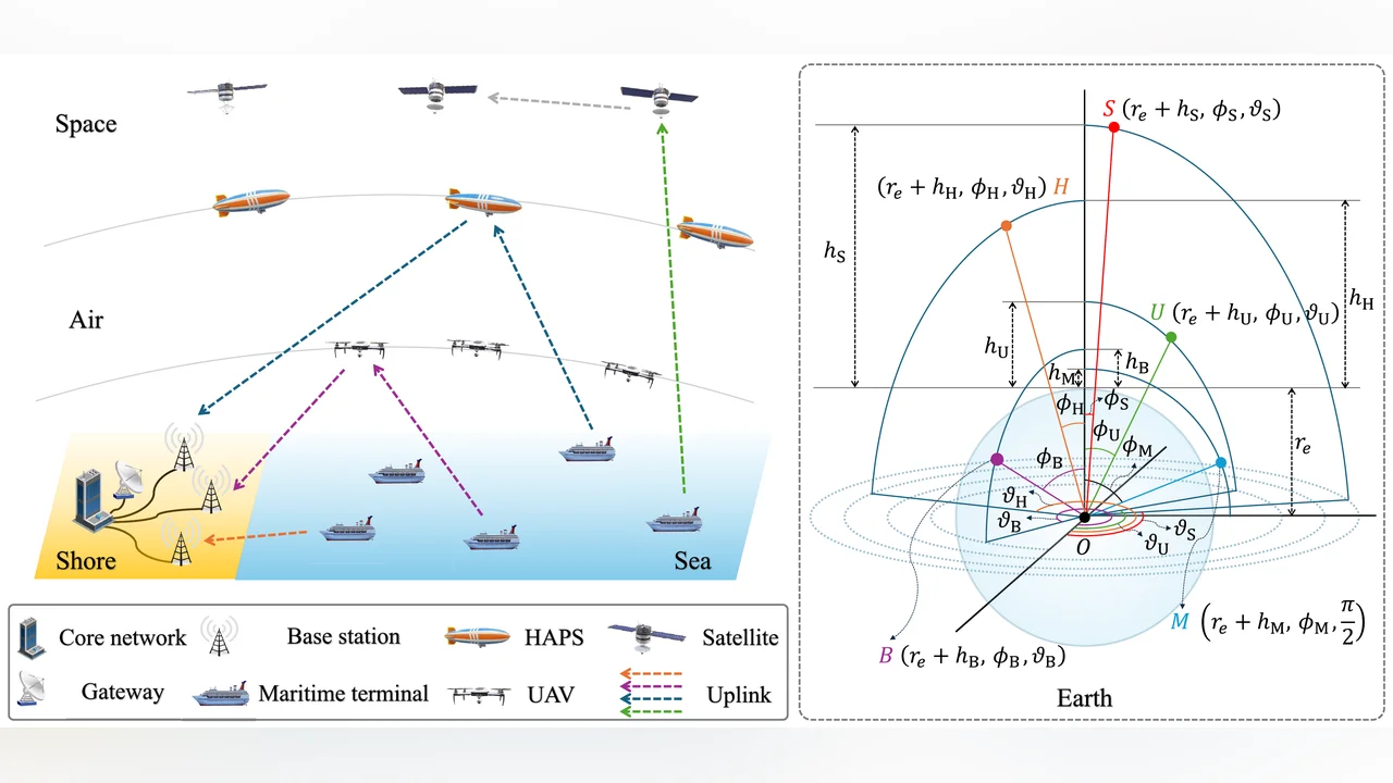
The proposed network gives a maritime terminal four ways to reach the core network. A ship close to shore connects directly to a coastal base station. Farther out, an uncrewed aerial vehicle (UAV) relays its signal to shore. Beyond UAV range, a high-altitude platform station (HAPS) in the stratosphere, at 17–22 km, takes over as the relay. In the far ocean, a terminal with a satellite-compatible radio front end connects to a low Earth orbit (LEO) satellite.
Modeling the network on a sphere
Large ocean networks are hard to evaluate by simulation alone, because each run must place many nodes over very large areas. Stochastic geometry instead treats node locations as random patterns and gives average performance in analytical form. Most such models assume that nodes lie on a flat plane. That assumption fails for high-altitude nodes, where the Earth’s curvature limits line of sight.
The team therefore placed all devices on concentric spheres around the Earth’s center. Base stations, UAVs, and HAPS are modeled with a Matérn hard-core point process extended to the sphere, which keeps a minimum distance between neighboring nodes and reflects real spacing rules that prevent overcrowding and collisions. Satellites are spread uniformly over their orbital shell. The channel models capture line-of-sight propagation over the open sea, shadowing on satellite links, rain attenuation, and losses from imperfect Doppler compensation.
For relay links, the framework does not simply pick the nearest UAV or HAPS. It selects the relay that maximizes the end-to-end capacity across both hops.
From coverage to QoS
Being connected is not the same as being well served. Beyond coverage, the authors define a communication probability: the chance that a link both decodes the signal and delivers the data rate an application needs. They illustrate it with three classes: low demand (voice calls and sensor data), medium demand (image sharing and web browsing), and high demand (video streaming and remote control of offshore platforms). The framework can handle any number of classes.
“Planar models miss how the Earth’s curvature limits high-altitude links,” said Dr. Zhengying Lou. “Working on the sphere shows exactly where each layer of the network takes over as a ship moves offshore.”
Key findings
The analytical results closely matched Monte Carlo simulations averaged over 10,000 trials. Coverage of the direct base-station link falls quickly beyond about 11 km offshore. Adding UAV relays extends reliable coverage to about 110 km, and HAPS relays extend it to about 550 km. With satellite access, coverage probability stays above 0.9 even far offshore. Compared with existing networks made only of base stations and satellites, the SAGSIN performs much better for terminals between 20 and 500 km from the coast.
QoS demands change the picture. Low-demand terminals keep a communication probability of 1 up to about 500 km and about 0.95 beyond it. For medium demand, the drop starts at about 400 km and levels off at 0.86. High-demand terminals stay fully served within 20 km, hold at 0.71 between 50 and 100 km, and lose service rapidly beyond 100 km.
The team also showed that dynamic QoS scheduling helps when demands are mixed. Assigning more high-rate traffic to UAV links, which have strong channels, and steering low- and medium-rate traffic to satellite links, which suffer high path loss, raises the overall communication probability.
“The goal is a tool operators can use before they deploy,” said Dr. Jiajie Xu. “Given a distance from shore and a deployment density, our expressions predict what service a terminal can expect, without running large simulations.”
Why it matters
The framework gives network planners a fast way to estimate performance from the coast to the open ocean, size base-station and relay deployments, and match traffic types to suitable links. The work supports the UNESCO Chair’s mission of connecting the unconnected, extending broadband-class service to one of the least connected regions on Earth.
More information can be found in the paper:
Related People

Zhengying Lou
- Ph.D. Student, Electrical and Computer Engineering

Baha Eddine Youcef Belmekki
- Postdoctoral Research Fellow, Electrical and Computer Engineering
Mohamed-Slim Alouini
- Al-Khawarzmi Distinguished Professor, Electrical and Computer Engineering